Thank you for supporting this site ❤️
Make a donation
Make a donation
Gear up for your next adventure:
As an Amazon Associate, this site earns from qualifying purchases at no extra cost to you.
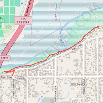
Norcobstream Trail
- Distance: 1.6 mi
- Elevation gain: 98 ft
- Maximum elevation: 646 ft
- Elevation loss: 89 ft
- Minimum elevation: 604 ft
- Moving time: 9 m 58 s
- Moving speed: 9.6 mph
- Maximum speed: 17.3 mph
- Total time: 10 m 43 s
- Global speed: 8.9 mph
Interactive trail map
Thank you for supporting this site ❤️
Make a donation
Make a donation
Gear up for your next adventure:
As an Amazon Associate, this site earns from qualifying purchases at no extra cost to you.
Trail profile
- Distance: 1.6 mi
- Elevation gain: 98 ft
- Maximum elevation: 646 ft
- Elevation loss: 89 ft
- Minimum elevation: 604 ft
- Moving time: 9 m 58 s
- Moving speed: 9.6 mph
- Maximum speed: 17.3 mph
- Total time: 10 m 43 s
- Global speed: 8.9 mph
Thank you for supporting this site ❤️
Make a donation
Make a donation
Gear up for your next adventure:
As an Amazon Associate, this site earns from qualifying purchases at no extra cost to you.
About this trail
Name: Norcobstream Trail trail, distance, elevation, map, profile, GPS track
Start: 1080, River Drive, Norco, Riverside County, California, 92860, United States (33.94845 -117.54526)
Coordinates: 33.94571 -117.55350 33.95205 -117.53883
Topography: Riverside County topographic map, elevation, terrain
Thank you for supporting this site ❤️
Make a donation
Make a donation
Gear up for your next adventure:
As an Amazon Associate, this site earns from qualifying purchases at no extra cost to you.