Make a donation
Gear up for your next adventure:
As an Amazon Associate, this site earns from qualifying purchases at no extra cost to you.
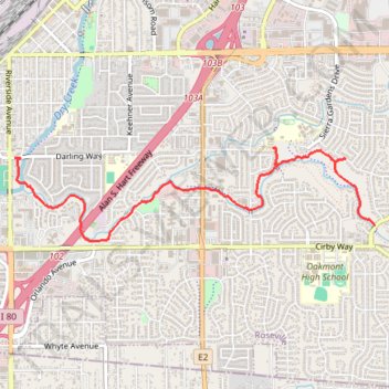
Dry Creek Greenway
- Distance: 3.3 mi
- Elevation gain: 85 ft
- Maximum elevation: 174 ft
- Elevation loss: 75 ft
- Minimum elevation: 135 ft
- Moving time: 13 m 42 s
- Moving speed: 14.4 mph
- Maximum speed: 25.1 mph
- Total time: 13 m 42 s
- Global speed: 14.4 mph
Interactive trail map
Make a donation
Gear up for your next adventure:
As an Amazon Associate, this site earns from qualifying purchases at no extra cost to you.
Trail profile
- Distance: 3.3 mi
- Elevation gain: 85 ft
- Maximum elevation: 174 ft
- Elevation loss: 75 ft
- Minimum elevation: 135 ft
- Moving time: 13 m 42 s
- Moving speed: 14.4 mph
- Maximum speed: 25.1 mph
- Total time: 13 m 42 s
- Global speed: 14.4 mph
Make a donation
Gear up for your next adventure:
As an Amazon Associate, this site earns from qualifying purchases at no extra cost to you.
About this trail
Name: Dry Creek Greenway trail, distance, elevation, map, profile, GPS track
Start: 142, Darling Way, Roseville, Placer County, California, 95678, United States (38.73616 -121.29006)
End: Rocky Ridge Drive, Roseville, Placer County, California, 95661, United States (38.73105 -121.25555)
Coordinates: 38.72991 -121.29006 38.73691 -121.25550
Topography: Roseville topographic map, elevation, terrain
Make a donation
Gear up for your next adventure:
As an Amazon Associate, this site earns from qualifying purchases at no extra cost to you.