Thank you for supporting this site ❤️
Make a donation
Make a donation
Gear up for your next adventure:
As an Amazon Associate, this site earns from qualifying purchases at no extra cost to you.
Mount Baden-Powell
Interactive trail map
Thank you for supporting this site ❤️
Make a donation
Make a donation
Gear up for your next adventure:
As an Amazon Associate, this site earns from qualifying purchases at no extra cost to you.
Trail profile
- Distance: 4.3 mi
- Elevation gain: 2,283 ft
- Maximum elevation: 9,377 ft
- Elevation loss: 873 ft
- Minimum elevation: 7,959 ft
Thank you for supporting this site ❤️
Make a donation
Make a donation
Gear up for your next adventure:
As an Amazon Associate, this site earns from qualifying purchases at no extra cost to you.
About this trail
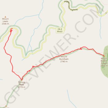
Name: Mount Baden-Powell trail, distance, elevation, map, profile, GPS track
Start: Dawson Saddle Trail, Los Angeles County, California, United States (34.36803 -117.80295)
Coordinates: 34.35039 -117.80645 34.36803 -117.76467
Topography: Los Angeles County topographic map, elevation, terrain
Thank you for supporting this site ❤️
Make a donation
Make a donation
Gear up for your next adventure:
As an Amazon Associate, this site earns from qualifying purchases at no extra cost to you.
Other hiking, mountain biking, running and outdoor activity trails
Click on a trail to view its statistics, map and profile.