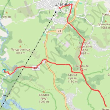
Cigota
CIGOTA1-02 15:53:45
- Distance: 8.5 mi
- Elevation gain: 1,745 ft
- Maximum elevation: 4,436 ft
- Elevation loss: 1,923 ft
- Minimum elevation: 3,127 ft
- Moving time: 4 h 33 m
- Moving speed: 1.9 mph
- Maximum speed: 3.6 mph
- Total time: 6 h 59 m
- Global speed: 1.2 mph
Interactive trail map
Trail profile
- Distance: 8.5 mi
- Elevation gain: 1,745 ft
- Maximum elevation: 4,436 ft
- Elevation loss: 1,923 ft
- Minimum elevation: 3,127 ft
- Moving time: 4 h 33 m
- Moving speed: 1.9 mph
- Maximum speed: 3.6 mph
- Total time: 6 h 59 m
- Global speed: 1.2 mph
About this trail
Name: Cigota trail, distance, elevation, map, profile, GPS track
Coordinates: 43.68310 19.66441 43.72651 19.72459
Other hiking, mountain biking, running and outdoor activity trails
Click on a trail to view its statistics, map and profile.
2022_Yu
Slovenia > Ajdovščina > Žapuže
Distance: 1,526.9 mi • Elevation gain: 105,144 ft • Maximum elevation: 6,398 ft