Thank you for supporting this site ❤️
Make a donation
Make a donation
Gear up for your next adventure:
As an Amazon Associate, this site earns from qualifying purchases at no extra cost to you.
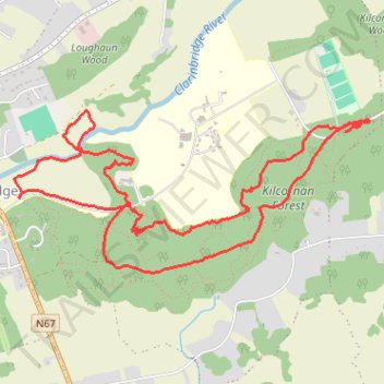
Clarinbridge trails in Kilcornan Forest
- Distance: 4.7 mi
- Elevation gain: 167 ft
- Maximum elevation: 89 ft
- Elevation loss: 167 ft
- Minimum elevation: 13 ft
- Moving time: 1 h 54 m
- Moving speed: 2.5 mph
- Maximum speed: 4.7 mph
- Total time: 2 h 11 m
- Global speed: 2.2 mph
Interactive trail map
Thank you for supporting this site ❤️
Make a donation
Make a donation
Gear up for your next adventure:
As an Amazon Associate, this site earns from qualifying purchases at no extra cost to you.
Trail profile
- Distance: 4.7 mi
- Elevation gain: 167 ft
- Maximum elevation: 89 ft
- Elevation loss: 167 ft
- Minimum elevation: 13 ft
- Moving time: 1 h 54 m
- Moving speed: 2.5 mph
- Maximum speed: 4.7 mph
- Total time: 2 h 11 m
- Global speed: 2.2 mph
Thank you for supporting this site ❤️
Make a donation
Make a donation
Gear up for your next adventure:
As an Amazon Associate, this site earns from qualifying purchases at no extra cost to you.
About this trail
Name: Clarinbridge trails in Kilcornan Forest trail, distance, elevation, map, profile, GPS track
Coordinates: 53.22355 -8.87732 53.23165 -8.84776
Thank you for supporting this site ❤️
Make a donation
Make a donation
Gear up for your next adventure:
As an Amazon Associate, this site earns from qualifying purchases at no extra cost to you.