Make a donation
Gear up for your next adventure:
As an Amazon Associate, this site earns from qualifying purchases at no extra cost to you.
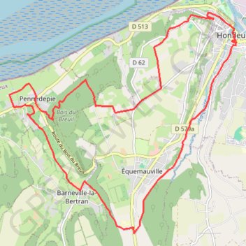
Honfleur Loop 19km
- Distance: 11.6 mi
- Elevation gain: 1,040 ft
- Maximum elevation: 397 ft
- Elevation loss: 1,043 ft
- Minimum elevation: 13 ft
Interactive trail map
Make a donation
Gear up for your next adventure:
As an Amazon Associate, this site earns from qualifying purchases at no extra cost to you.
Trail profile
- Distance: 11.6 mi
- Elevation gain: 1,040 ft
- Maximum elevation: 397 ft
- Elevation loss: 1,043 ft
- Minimum elevation: 13 ft
Make a donation
Gear up for your next adventure:
As an Amazon Associate, this site earns from qualifying purchases at no extra cost to you.
About this trail
Name: Honfleur Loop 19km trail, distance, elevation, map, profile, GPS track
Coordinates: 49.38217 0.16905 49.42392 0.23516
Make a donation
Gear up for your next adventure:
As an Amazon Associate, this site earns from qualifying purchases at no extra cost to you.
Other hiking, mountain biking, running and outdoor activity trails
Click on a trail to view its statistics, map and profile.
Trouville Honfleur 18km
France > Normandy > Calvados > Trouville-sur-Mer
Distance: 11.1 mi • Elevation gain: 1,355 ft • Maximum elevation: 404 ft
Cabourg Honfleur
France > Normandy > Calvados > Cabourg
Distance: 28.0 mi • Elevation gain: 1,850 ft • Maximum elevation: 492 ft
Honfleur Loop 19km
France > Normandy > Calvados > Honfleur
Distance: 11.6 mi • Elevation gain: 1,033 ft • Maximum elevation: 397 ft