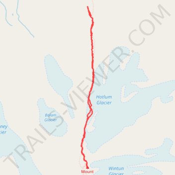
Hotlum Bolam Ridge, Mount Shasta
- Distance: 4.3 mi
- Elevation gain: 4,331 ft
- Maximum elevation: 14,137 ft
- Elevation loss: 4,331 ft
- Minimum elevation: 9,849 ft
- Moving time: 4 h 10 m
- Moving speed: 1.0 mph
- Maximum speed: 2.5 mph
- Total time: 10 h 52 m
- Global speed: 0.4 mph
Interactive trail map
Trail profile
- Distance: 4.3 mi
- Elevation gain: 4,331 ft
- Maximum elevation: 14,137 ft
- Elevation loss: 4,331 ft
- Minimum elevation: 9,849 ft
- Moving time: 4 h 10 m
- Moving speed: 1.0 mph
- Maximum speed: 2.5 mph
- Total time: 10 h 52 m
- Global speed: 0.4 mph
About this trail
Name: Hotlum Bolam Ridge, Mount Shasta trail, distance, elevation, map, profile, GPS track
Start: Hotlum Bolum Ridge, Siskiyou County, California, United States (41.43482 -122.19486)
End: Hotlum Bolum Ridge, Siskiyou County, California, United States (41.43482 -122.19486)
Coordinates: 41.40897 -122.19613 41.43482 -122.19347
Topography: Siskiyou County topographic map, elevation, terrain