Darlington Trail and Other Trails in State Game Lands Number 170
- Distance: 3.6 mi
- Elevation gain: 384 ft
- Maximum elevation: 1,234 ft
- Elevation loss: 381 ft
- Minimum elevation: 971 ft
- Moving time: 1 h 9 m
- Moving speed: 3.1 mph
- Maximum speed: 10.2 mph
- Total time: 1 h 9 m
- Global speed: 3.1 mph
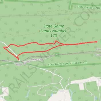
Interactive trail map
Trail profile
- Distance: 3.6 mi
- Elevation gain: 384 ft
- Maximum elevation: 1,234 ft
- Elevation loss: 381 ft
- Minimum elevation: 971 ft
- Moving time: 1 h 9 m
- Moving speed: 3.1 mph
- Maximum speed: 10.2 mph
- Total time: 1 h 9 m
- Global speed: 3.1 mph
About this trail
Name: Darlington Trail and Other Trails in State Game Lands Number 170 trail, distance, elevation, map, profile, GPS track
Coordinates: 40.30242 -77.06872 40.30708 -77.03888
Topography: Rye Township topographic map, elevation, terrain
Other hiking, mountain biking, running and outdoor activity trails
Click on a trail to view its statistics, map and profile.
Darlington, Appalachian, and other State Game Lands Number 170 trails
United States > Pennsylvania > Perry County > Rye Township
Distance: 4.9 mi • Elevation gain: 702 ft • Maximum elevation: 1,299 ft