Make a donation
Gear up for your next adventure:
As an Amazon Associate, this site earns from qualifying purchases at no extra cost to you.
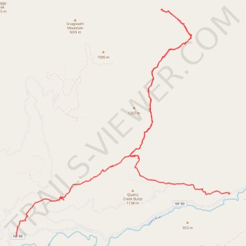
Quartz Creek, French Creek, and Quartz Creek Butte Hike
- Distance: 23.8 mi
- Elevation gain: 6,932 ft
- Maximum elevation: 3,373 ft
- Elevation loss: 6,411 ft
- Minimum elevation: 1,804 ft
- Moving time: 14 h 4 m
- Moving speed: 1.7 mph
- Maximum speed: 4.3 mph
- Total time: 2 d 10 h
- Global speed: 0.4 mph
Interactive trail map
Make a donation
Gear up for your next adventure:
As an Amazon Associate, this site earns from qualifying purchases at no extra cost to you.
Trail profile
- Distance: 23.8 mi
- Elevation gain: 6,932 ft
- Maximum elevation: 3,373 ft
- Elevation loss: 6,411 ft
- Minimum elevation: 1,804 ft
- Moving time: 14 h 4 m
- Moving speed: 1.7 mph
- Maximum speed: 4.3 mph
- Total time: 2 d 10 h
- Global speed: 0.4 mph
Make a donation
Gear up for your next adventure:
As an Amazon Associate, this site earns from qualifying purchases at no extra cost to you.
About this trail
Name: Quartz Creek, French Creek, and Quartz Creek Butte Hike trail, distance, elevation, map, profile, GPS track
Start: Lewis River Trail, Skamania County, Washington, United States (46.18246 -121.84906)
End: Lewis River Road, Skamania County, Washington, United States (46.19684 -121.74539)
Coordinates: 46.18246 -121.84939 46.25949 -121.74472
Topography: Skamania County topographic map, elevation, terrain
Make a donation
Gear up for your next adventure:
As an Amazon Associate, this site earns from qualifying purchases at no extra cost to you.
Other hiking, mountain biking, running and outdoor activity trails
Click on a trail to view its statistics, map and profile.
Northern part of the Pacific Crest Trail (PCT)
United States > Oregon > Klamath County
Hike on the Pacific Crest National Scenic Trail from Crater Lake to Canada Border through Oregon and Washington along the Sierra Nevada and Cascade mountain ranges. #Hiking #Mountain #SierraNevada #Cascade #Nature #Forest #Park #PCT
Distance: 744.6 mi • Elevation gain: 145,367 ft • Maximum elevation: 7,569 ft