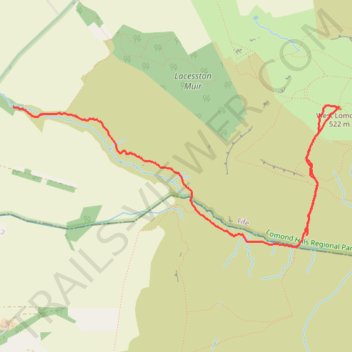
Walk to West Lomond via John Knox Pulpit route
- Distance: 3.2 mi
- Elevation gain: 748 ft
- Maximum elevation: 1,693 ft
- Elevation loss: 1,152 ft
- Minimum elevation: 538 ft
- Moving time: 1 h 5 m
- Moving speed: 2.9 mph
- Maximum speed: 5.0 mph
- Total time: 1 h 6 m
- Global speed: 2.9 mph
Interactive trail map
Trail profile
- Distance: 3.2 mi
- Elevation gain: 748 ft
- Maximum elevation: 1,693 ft
- Elevation loss: 1,152 ft
- Minimum elevation: 538 ft
- Moving time: 1 h 5 m
- Moving speed: 2.9 mph
- Maximum speed: 5.0 mph
- Total time: 1 h 6 m
- Global speed: 2.9 mph
About this trail
Name: Walk to West Lomond via John Knox Pulpit route trail, distance, elevation, map, profile, GPS track
Start: Gateside, Fife, Scotland, KY14 7SY, United Kingdom (56.23691 -3.30071)
End: Dryside Road, Fife, Scotland, KY14 7RP, United Kingdom (56.24547 -3.33604)
Coordinates: 56.23615 -3.33604 56.24560 -3.29691