Thank you for supporting this site ❤️
Make a donation
Make a donation
Gear up for your next adventure:
As an Amazon Associate, this site earns from qualifying purchases at no extra cost to you.
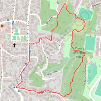
Loop walk via City to Sea Walkway in Prince of Wales Park
- Distance: 1.5 mi
- Elevation gain: 390 ft
- Maximum elevation: 584 ft
- Elevation loss: 390 ft
- Minimum elevation: 253 ft
- Moving time: 33 m 24 s
- Moving speed: 2.6 mph
- Maximum speed: 3.7 mph
- Total time: 33 m 24 s
- Global speed: 2.6 mph
Interactive trail map
Thank you for supporting this site ❤️
Make a donation
Make a donation
Gear up for your next adventure:
As an Amazon Associate, this site earns from qualifying purchases at no extra cost to you.
Trail profile
- Distance: 1.5 mi
- Elevation gain: 390 ft
- Maximum elevation: 584 ft
- Elevation loss: 390 ft
- Minimum elevation: 253 ft
- Moving time: 33 m 24 s
- Moving speed: 2.6 mph
- Maximum speed: 3.7 mph
- Total time: 33 m 24 s
- Global speed: 2.6 mph
Thank you for supporting this site ❤️
Make a donation
Make a donation
Gear up for your next adventure:
As an Amazon Associate, this site earns from qualifying purchases at no extra cost to you.
About this trail
Name: Loop walk via City to Sea Walkway in Prince of Wales Park trail, distance, elevation, map, profile, GPS track
Coordinates: -41.31012 174.76565 -41.30384 174.77184
Thank you for supporting this site ❤️
Make a donation
Make a donation
Gear up for your next adventure:
As an Amazon Associate, this site earns from qualifying purchases at no extra cost to you.
Other hiking, mountain biking, running and outdoor activity trails
Click on a trail to view its statistics, map and profile.
Welington
New Zealand > Wellington > Wellington City > Wellington
Distance: 46.3 mi • Elevation gain: 2,907 ft • Maximum elevation: 732 ft