Make a donation
Gear up for your next adventure:
As an Amazon Associate, this site earns from qualifying purchases at no extra cost to you.
Erminskine Park and Lands
- Distance: 3.5 mi
- Elevation gain: 200 ft
- Maximum elevation: 262 ft
- Elevation loss: 200 ft
- Minimum elevation: 138 ft
- Moving time: 1 h 16 m
- Moving speed: 2.8 mph
- Maximum speed: 4.9 mph
- Total time: 1 h 35 m
- Global speed: 2.2 mph
Interactive trail map
Make a donation
Gear up for your next adventure:
As an Amazon Associate, this site earns from qualifying purchases at no extra cost to you.
Trail profile
- Distance: 3.5 mi
- Elevation gain: 200 ft
- Maximum elevation: 262 ft
- Elevation loss: 200 ft
- Minimum elevation: 138 ft
- Moving time: 1 h 16 m
- Moving speed: 2.8 mph
- Maximum speed: 4.9 mph
- Total time: 1 h 35 m
- Global speed: 2.2 mph
Make a donation
Gear up for your next adventure:
As an Amazon Associate, this site earns from qualifying purchases at no extra cost to you.
About this trail
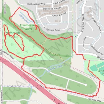
Name: Erminskine Park and Lands trail, distance, elevation, map, profile, GPS track
Coordinates: 49.30817 -124.34563 49.31755 -124.33026
Make a donation
Gear up for your next adventure:
As an Amazon Associate, this site earns from qualifying purchases at no extra cost to you.
Other hiking, mountain biking, running and outdoor activity trails
Click on a trail to view its statistics, map and profile.
Sproat Lake - Nanaimo
Canada > British Columbia > Alberni-Clayoquot Regional District > Area D (Sproat Lake)
Distance: 54.0 mi • Elevation gain: 4,177 ft • Maximum elevation: 1,385 ft
Parks paths
Canada > British Columbia > Regional District of Nanaimo > Parksville
Distance: 30.3 mi • Elevation gain: 3,012 ft • Maximum elevation: 1,391 ft