Thank you for supporting this site ❤️
Make a donation
Make a donation
Gear up for your next adventure:
As an Amazon Associate, this site earns from qualifying purchases at no extra cost to you.
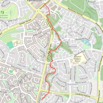
Palmerston Escarpment Trail
- Distance: 2.2 mi
- Elevation gain: 112 ft
- Maximum elevation: 164 ft
- Elevation loss: 62 ft
- Minimum elevation: 105 ft
- Moving time: 55 m 45 s
- Moving speed: 2.3 mph
- Maximum speed: 4.6 mph
- Total time: 1 h 13 m
- Global speed: 1.8 mph
Interactive trail map
Thank you for supporting this site ❤️
Make a donation
Make a donation
Gear up for your next adventure:
As an Amazon Associate, this site earns from qualifying purchases at no extra cost to you.
Trail profile
- Distance: 2.2 mi
- Elevation gain: 112 ft
- Maximum elevation: 164 ft
- Elevation loss: 62 ft
- Minimum elevation: 105 ft
- Moving time: 55 m 45 s
- Moving speed: 2.3 mph
- Maximum speed: 4.6 mph
- Total time: 1 h 13 m
- Global speed: 1.8 mph
Thank you for supporting this site ❤️
Make a donation
Make a donation
Gear up for your next adventure:
As an Amazon Associate, this site earns from qualifying purchases at no extra cost to you.
About this trail
Name: Palmerston Escarpment Trail trail, distance, elevation, map, profile, GPS track
Coordinates: -12.50242 130.98616 -12.48074 130.99074
Thank you for supporting this site ❤️
Make a donation
Make a donation
Gear up for your next adventure:
As an Amazon Associate, this site earns from qualifying purchases at no extra cost to you.