Zabriskie Point, Gower Gulch and Golden Canyon Loop (Death Valley)
Loop hike from Zabriskie Point via Badlands Loop, Gower Gulch Trail, Golden Canyon Trail and 360 Viewpoint in the Death Valley National Park. #Hiking #Loop #Nature #Rock #Canyon #Desert #Park #Overlook
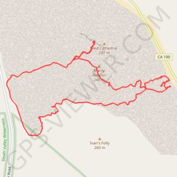
- Distance: 7.7 mi
- Elevation gain: 1,634 ft
- Maximum elevation: 669 ft
- Elevation loss: 1,624 ft
- Minimum elevation: -164 ft
- Moving time: 4 h 50 s
- Moving speed: 1.9 mph
- Maximum speed: 3.3 mph
- Total time: 4 h 39 m
- Global speed: 1.6 mph
Interactive trail map
Trail profile
- Distance: 7.7 mi
- Elevation gain: 1,634 ft
- Maximum elevation: 669 ft
- Elevation loss: 1,624 ft
- Minimum elevation: -164 ft
- Moving time: 4 h 50 s
- Moving speed: 1.9 mph
- Maximum speed: 3.3 mph
- Total time: 4 h 39 m
- Global speed: 1.6 mph
About this trail
Name: Zabriskie Point, Gower Gulch and Golden Canyon Loop (Death Valley) trail, distance, elevation, map, profile, GPS track
Start: Badlands Loop, Inyo County, California, United States (36.42105 -116.81032)
End: Zabriskie Point Trail, Inyo County, California, United States (36.42057 -116.81140)
Coordinates: 36.41104 -116.84673 36.42805 -116.81018
Topography: Inyo County topographic map, elevation, terrain
Other hiking, mountain biking, running and outdoor activity trails
Click on a trail to view its statistics, map and profile.