Thank you for supporting this site ❤️
Make a donation
Make a donation
Gear up for your next adventure:
As an Amazon Associate, this site earns from qualifying purchases at no extra cost to you.
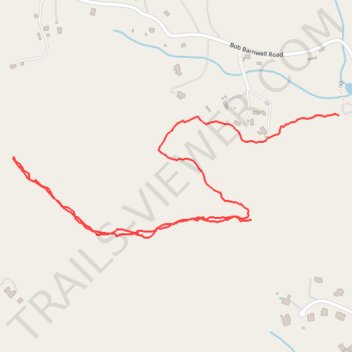
Buzzard's Roost Trail
- Distance: 1.7 mi
- Elevation gain: 243 ft
- Maximum elevation: 2,881 ft
- Elevation loss: 509 ft
- Minimum elevation: 2,369 ft
- Moving time: 59 m 38 s
- Moving speed: 1.7 mph
- Maximum speed: 3.8 mph
- Total time: 1 h 18 m
- Global speed: 1.3 mph
Interactive trail map
Thank you for supporting this site ❤️
Make a donation
Make a donation
Gear up for your next adventure:
As an Amazon Associate, this site earns from qualifying purchases at no extra cost to you.
Trail profile
- Distance: 1.7 mi
- Elevation gain: 243 ft
- Maximum elevation: 2,881 ft
- Elevation loss: 509 ft
- Minimum elevation: 2,369 ft
- Moving time: 59 m 38 s
- Moving speed: 1.7 mph
- Maximum speed: 3.8 mph
- Total time: 1 h 18 m
- Global speed: 1.3 mph
Thank you for supporting this site ❤️
Make a donation
Make a donation
Gear up for your next adventure:
As an Amazon Associate, this site earns from qualifying purchases at no extra cost to you.
About this trail
Name: Buzzard's Roost Trail trail, distance, elevation, map, profile, GPS track
Start: Buzzard's Roost Trail, Buncombe County, North Carolina, United States (35.50644 -82.45415)
End: Buzzard's Roost Trail, Buncombe County, North Carolina, United States (35.50913 -82.45137)
Coordinates: 35.50597 -82.46166 35.50915 -82.45137
Topography: Buncombe County topographic map, elevation, terrain
Thank you for supporting this site ❤️
Make a donation
Make a donation
Gear up for your next adventure:
As an Amazon Associate, this site earns from qualifying purchases at no extra cost to you.