Make a donation
Gear up for your next adventure:
As an Amazon Associate, this site earns from qualifying purchases at no extra cost to you.
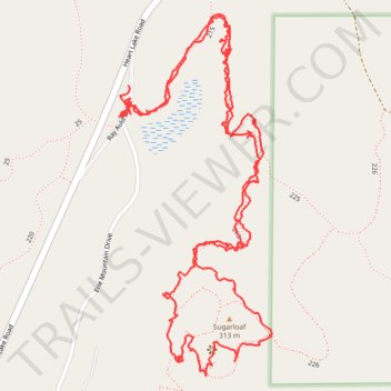
Around Sugarloaf Mountain, WA
- Distance: 2.8 mi
- Elevation gain: 725 ft
- Maximum elevation: 1,024 ft
- Elevation loss: 732 ft
- Minimum elevation: 420 ft
- Moving time: 1 h 10 m
- Moving speed: 2.4 mph
- Maximum speed: 20.1 mph
- Total time: 1 h 45 m
- Global speed: 1.6 mph
Interactive trail map
Make a donation
Gear up for your next adventure:
As an Amazon Associate, this site earns from qualifying purchases at no extra cost to you.
Trail profile
- Distance: 2.8 mi
- Elevation gain: 725 ft
- Maximum elevation: 1,024 ft
- Elevation loss: 732 ft
- Minimum elevation: 420 ft
- Moving time: 1 h 10 m
- Moving speed: 2.4 mph
- Maximum speed: 20.1 mph
- Total time: 1 h 45 m
- Global speed: 1.6 mph
Make a donation
Gear up for your next adventure:
As an Amazon Associate, this site earns from qualifying purchases at no extra cost to you.
About this trail
Name: Around Sugarloaf Mountain, WA trail, distance, elevation, map, profile, GPS track
Start: Ray Auld Drive, Anacortes, Skagit County, Washington, 98221, United States (48.46828 -122.62954)
End: Ray Auld Drive, Anacortes, Skagit County, Washington, 98221, United States (48.46773 -122.62973)
Coordinates: 48.46257 -122.62981 48.46967 -122.62529
Topography: Skagit County topographic map, elevation, terrain
Make a donation
Gear up for your next adventure:
As an Amazon Associate, this site earns from qualifying purchases at no extra cost to you.