Thank you for supporting this site ❤️
Make a donation
Make a donation
Gear up for your next adventure:
As an Amazon Associate, this site earns from qualifying purchases at no extra cost to you.
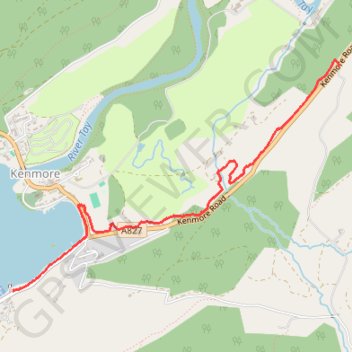
Taymouth Marina to Fort Lodge
Kenmore core path
- Distance: 2.0 mi
- Elevation gain: 404 ft
- Maximum elevation: 594 ft
- Elevation loss: 197 ft
- Minimum elevation: 364 ft
- Moving time: 49 m 27 s
- Moving speed: 2.5 mph
- Maximum speed: 3.5 mph
- Total time: 50 m 48 s
- Global speed: 2.4 mph
Interactive trail map
Thank you for supporting this site ❤️
Make a donation
Make a donation
Gear up for your next adventure:
As an Amazon Associate, this site earns from qualifying purchases at no extra cost to you.
Trail profile
- Distance: 2.0 mi
- Elevation gain: 404 ft
- Maximum elevation: 594 ft
- Elevation loss: 197 ft
- Minimum elevation: 364 ft
- Moving time: 49 m 27 s
- Moving speed: 2.5 mph
- Maximum speed: 3.5 mph
- Total time: 50 m 48 s
- Global speed: 2.4 mph
Thank you for supporting this site ❤️
Make a donation
Make a donation
Gear up for your next adventure:
As an Amazon Associate, this site earns from qualifying purchases at no extra cost to you.
About this trail
Name: Taymouth Marina to Fort Lodge trail, distance, elevation, map, profile, GPS track
Start: Kenmore, Perth and Kinross, Scotland, PH15 2HW, United Kingdom (56.57949 -4.00289)
End: Kenmore Road, Aberfeldy, Perth and Kinross, Scotland, PH15 2JL, United Kingdom (56.59132 -3.97180)
Coordinates: 56.57949 -4.00289 56.59162 -3.97176
Thank you for supporting this site ❤️
Make a donation
Make a donation
Gear up for your next adventure:
As an Amazon Associate, this site earns from qualifying purchases at no extra cost to you.