Thank you for supporting this site ❤️
Make a donation
Make a donation
Gear up for your next adventure:
As an Amazon Associate, this site earns from qualifying purchases at no extra cost to you.
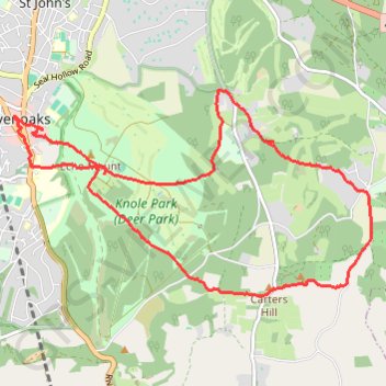
Sevenoaks Knole Park (Deer Park) Loop
- Distance: 8.0 mi
- Elevation gain: 745 ft
- Maximum elevation: 673 ft
- Elevation loss: 741 ft
- Minimum elevation: 417 ft
- Moving time: 2 h 41 m
- Moving speed: 3.0 mph
- Maximum speed: 7.0 mph
- Total time: 3 h 37 m
- Global speed: 2.2 mph
Interactive trail map
Thank you for supporting this site ❤️
Make a donation
Make a donation
Gear up for your next adventure:
As an Amazon Associate, this site earns from qualifying purchases at no extra cost to you.
Trail profile
- Distance: 8.0 mi
- Elevation gain: 745 ft
- Maximum elevation: 673 ft
- Elevation loss: 741 ft
- Minimum elevation: 417 ft
- Moving time: 2 h 41 m
- Moving speed: 3.0 mph
- Maximum speed: 7.0 mph
- Total time: 3 h 37 m
- Global speed: 2.2 mph
Thank you for supporting this site ❤️
Make a donation
Make a donation
Gear up for your next adventure:
As an Amazon Associate, this site earns from qualifying purchases at no extra cost to you.
About this trail
Name: Sevenoaks Knole Park (Deer Park) Loop trail, distance, elevation, map, profile, GPS track
Start: Knole Way, St John's, Sevenoaks, Kent, England, TN13 3RS, United Kingdom (51.27097 0.19569)
Coordinates: 51.25450 0.19138 51.27481 0.24740
Thank you for supporting this site ❤️
Make a donation
Make a donation
Gear up for your next adventure:
As an Amazon Associate, this site earns from qualifying purchases at no extra cost to you.