Delta Lake from Lupine Meadows Trailhead in Grand Teton National Park
This hike to Delta Lake is a challenging but rewarding adventure through stunning alpine scenery in Grand Teton National Park. Although the trail isn’t officially maintained, making the final stretch a bit tricky with some boulder scrambling, the crystal-clear lake at the top is absolutely worth the effort. The views of the towering peaks and the tranquil waters make this strenuous journey one you'll be proud to complete. #Hiking #Mountain #Lake #Forest #Nature #Rock
- Distance: 7.6 mi
- Elevation gain: 2,395 ft
- Maximum elevation: 9,052 ft
- Elevation loss: 2,395 ft
- Minimum elevation: 6,729 ft
- Moving time: 3 h 46 m
- Moving speed: 2.0 mph
- Maximum speed: 4.5 mph
- Total time: 6 h 16 m
- Global speed: 1.2 mph
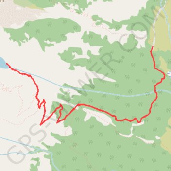
Interactive trail map
Trail profile
- Distance: 7.6 mi
- Elevation gain: 2,395 ft
- Maximum elevation: 9,052 ft
- Elevation loss: 2,395 ft
- Minimum elevation: 6,729 ft
- Moving time: 3 h 46 m
- Moving speed: 2.0 mph
- Maximum speed: 4.5 mph
- Total time: 6 h 16 m
- Global speed: 1.2 mph
About this trail
Name: Delta Lake from Lupine Meadows Trailhead in Grand Teton National Park trail, distance, elevation, map, profile, GPS track
Start: Lupine Meadows Trailhead, Apex Trail, Teton County, Wyoming, United States (43.73510 -110.74129)
End: Lupine Meadows Trailhead, Apex Trail, Teton County, Wyoming, United States (43.73475 -110.74145)
Coordinates: 43.72322 -110.77182 43.73510 -110.73888
Topography: Teton County topographic map, elevation, terrain
Other hiking, mountain biking, running and outdoor activity trails
Click on a trail to view its statistics, map and profile.
Delta Lake via Amphitheater Lake Trail
United States > Wyoming > Teton County
Distance: 6.9 mi • Elevation gain: 2,339 ft • Maximum elevation: 9,045 ft