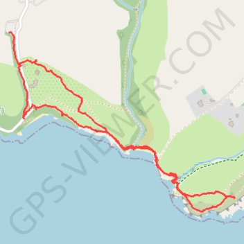
Durgan to Mawnan walk
- Distance: 2.1 mi
- Elevation gain: 367 ft
- Maximum elevation: 194 ft
- Elevation loss: 341 ft
- Minimum elevation: 3 ft
- Moving time: 55 m 4 s
- Moving speed: 2.3 mph
- Maximum speed: 3.9 mph
- Total time: 1 h 32 m
- Global speed: 1.4 mph
Interactive trail map
Trail profile
- Distance: 2.1 mi
- Elevation gain: 367 ft
- Maximum elevation: 194 ft
- Elevation loss: 341 ft
- Minimum elevation: 3 ft
- Moving time: 55 m 4 s
- Moving speed: 2.3 mph
- Maximum speed: 3.9 mph
- Total time: 1 h 32 m
- Global speed: 1.4 mph
About this trail
Name: Durgan to Mawnan walk trail, distance, elevation, map, profile, GPS track
Coordinates: 50.09994 -5.11395 50.10744 -5.09921
Other hiking, mountain biking, running and outdoor activity trails
Click on a trail to view its statistics, map and profile.
Mawnan Smith loop
United Kingdom > England > Cornwall > Falmouth > Bareppa
Cornwall Road Cycling
Distance: 34.1 mi • Elevation gain: 3,038 ft • Maximum elevation: 663 ft
Mawnan Helford loop
United Kingdom > England > Cornwall > Falmouth > Carlidnack
Distance: 7.2 mi • Elevation gain: 922 ft • Maximum elevation: 318 ft
Mawnan Smith Loop
United Kingdom > England > Cornwall > Falmouth > Carlidnack
Distance: 6.6 mi • Elevation gain: 863 ft • Maximum elevation: 259 ft