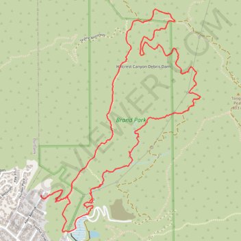
Brand Park Loop (Verdugo Mountains)
Starting near Brand Park, a foothill park at the base of the Verdugo Mountains, the loop leaves the landscaped edge of Glendale toward Brand Debris Basin, the Bamboo Ruins Trail, and the lower folds of Brand Canyon.
The route then climbs Brand Motorway through chaparral-covered slopes and open switchbacks to reach Verdugo Motorway, where the terrain becomes broader and more exposed along the Verdugo Mountains ridge.
The return follows Skyline Motorway and descending hillside tracks, with wide views toward Glendale, Burbank, the San Fernando Valley, Griffith Park, and the surrounding mountain ranges before dropping back to Brand Park.
#Hiking #Loop #Mountain #Nature #Forest #Canyon #Ridge #Views
- Distance: 5.9 mi
- Elevation gain: 2,592 ft
- Maximum elevation: 2,828 ft
- Elevation loss: 2,592 ft
- Minimum elevation: 915 ft
- Moving time: 3 h 14 m
- Moving speed: 1.8 mph
- Maximum speed: 4.2 mph
- Total time: 4 h 31 m
- Global speed: 1.3 mph
Interactive trail map
Trail profile
- Distance: 5.9 mi
- Elevation gain: 2,592 ft
- Maximum elevation: 2,828 ft
- Elevation loss: 2,592 ft
- Minimum elevation: 915 ft
- Moving time: 3 h 14 m
- Moving speed: 1.8 mph
- Maximum speed: 4.2 mph
- Total time: 4 h 31 m
- Global speed: 1.3 mph
About this trail
Name: Brand Park Loop (Verdugo Mountains) trail, distance, elevation, map, profile, GPS track
Coordinates: 34.18500 -118.28013 34.20462 -118.26317
Topography: Glendale topographic map, elevation, terrain
Other hiking, mountain biking, running and outdoor activity trails
Click on a trail to view its statistics, map and profile.
Verdugo Mountains Full Ridge
United States > California > Los Angeles County > Los Angeles
Hike on the Verdugo Mountains via Village Avenue Trail, La Tuna Peak, Chandler Mtrwy, Boy Scout Camp, Verdugo Motorway, Verdugo Crest Trail, Tree of Life, Wildhos Saddle, Verdugo Peak, Mesa Lila Road, Mount Thom and Las Flores Motorway. #Hiking #Mountain #Nature #Forest #Park
Distance: 14.5 mi • Elevation gain: 3,852 ft • Maximum elevation: 3,104 ft