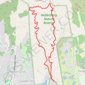
Helderberg Nature Reserve Loop
Loop hike in the Helderberg Nature Reserve via Protea Trail, Leopard Loop, Waboom Trail and Watsonia Trail. #Hiking #Loop #Nature
- Distance: 5.8 mi
- Elevation gain: 1,634 ft
- Maximum elevation: 1,870 ft
- Elevation loss: 1,631 ft
- Minimum elevation: 367 ft
- Moving time: 2 h 41 m
- Moving speed: 2.2 mph
- Maximum speed: 3.5 mph
- Total time: 2 h 50 m
- Global speed: 2.1 mph
Interactive trail map
Trail profile
- Distance: 5.8 mi
- Elevation gain: 1,634 ft
- Maximum elevation: 1,870 ft
- Elevation loss: 1,631 ft
- Minimum elevation: 367 ft
- Moving time: 2 h 41 m
- Moving speed: 2.2 mph
- Maximum speed: 3.5 mph
- Total time: 2 h 50 m
- Global speed: 2.1 mph
About this trail
Name: Helderberg Nature Reserve Loop trail, distance, elevation, map, profile, GPS track
Coordinates: -34.06699 18.86568 -34.04117 18.87618