Make a donation
Gear up for your next adventure:
As an Amazon Associate, this site earns from qualifying purchases at no extra cost to you.
摩星嶺北坑
- Distance: 1.7 mi
- Elevation gain: 801 ft
- Maximum elevation: 794 ft
- Elevation loss: 725 ft
- Minimum elevation: 72 ft
- Moving time: 1 h 3 m
- Moving speed: 1.6 mph
- Maximum speed: 6.3 mph
- Total time: 1 h 27 m
- Global speed: 1.2 mph
Interactive trail map
Make a donation
Gear up for your next adventure:
As an Amazon Associate, this site earns from qualifying purchases at no extra cost to you.
Trail profile
- Distance: 1.7 mi
- Elevation gain: 801 ft
- Maximum elevation: 794 ft
- Elevation loss: 725 ft
- Minimum elevation: 72 ft
- Moving time: 1 h 3 m
- Moving speed: 1.6 mph
- Maximum speed: 6.3 mph
- Total time: 1 h 27 m
- Global speed: 1.2 mph
Make a donation
Gear up for your next adventure:
As an Amazon Associate, this site earns from qualifying purchases at no extra cost to you.
About this trail
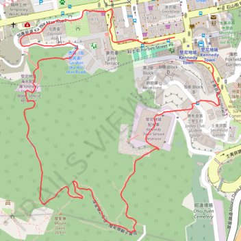
Name: 摩星嶺北坑 trail, distance, elevation, map, profile, GPS track
End: Kennedy Town, Central and Western District, Hong Kong Island, Hong Kong, China (22.28086 114.12835)
Coordinates: 22.27647 114.12377 22.28216 114.12928
Make a donation
Gear up for your next adventure:
As an Amazon Associate, this site earns from qualifying purchases at no extra cost to you.
Other hiking, mountain biking, running and outdoor activity trails
Click on a trail to view its statistics, map and profile.
HK dino
China > Hong Kong > Hong Kong Island
Loop hike from Kennedy Town via Lung Fu Shan, High West, Victoria Peak, Pok Fu Lam Reservoir and Mount Davis in the Lung Fu Shan Country Park and the Pok Fu Lam Country Park. #Hiking #Loop #Nature #Mountain #Forest #Sea #Pacific #Ocean #Park
Distance: 15.2 mi • Elevation gain: 4,347 ft • Maximum elevation: 1,736 ft
Trail Planner Map
China > Hong Kong > Hong Kong Island
Distance: 12.6 mi • Elevation gain: 3,776 ft • Maximum elevation: 1,388 ft
摩星嶺北右坑
China > Hong Kong > Hong Kong Island
Loop hike
Distance: 2.5 mi • Elevation gain: 932 ft • Maximum elevation: 784 ft
西寧坑
China > Hong Kong > Hong Kong Island
Hong Kong Island Hike
Distance: 2.3 mi • Elevation gain: 866 ft • Maximum elevation: 699 ft
Make a donation
Gear up for your next adventure:
As an Amazon Associate, this site earns from qualifying purchases at no extra cost to you.