Thank you for supporting this site ❤️
Make a donation
Make a donation
Gear up for your next adventure:
As an Amazon Associate, this site earns from qualifying purchases at no extra cost to you.
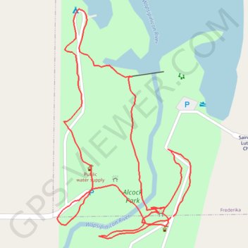
Alcock Park Loop
- Distance: 1.2 mi
- Elevation gain: 30 ft
- Maximum elevation: 1,037 ft
- Elevation loss: 30 ft
- Minimum elevation: 1,017 ft
- Moving time: 32 m 19 s
- Moving speed: 2.3 mph
- Maximum speed: 6.3 mph
- Total time: 39 m 53 s
- Global speed: 1.8 mph
Interactive trail map
Thank you for supporting this site ❤️
Make a donation
Make a donation
Gear up for your next adventure:
As an Amazon Associate, this site earns from qualifying purchases at no extra cost to you.
Trail profile
- Distance: 1.2 mi
- Elevation gain: 30 ft
- Maximum elevation: 1,037 ft
- Elevation loss: 30 ft
- Minimum elevation: 1,017 ft
- Moving time: 32 m 19 s
- Moving speed: 2.3 mph
- Maximum speed: 6.3 mph
- Total time: 39 m 53 s
- Global speed: 1.8 mph
Thank you for supporting this site ❤️
Make a donation
Make a donation
Gear up for your next adventure:
As an Amazon Associate, this site earns from qualifying purchases at no extra cost to you.
About this trail
Name: Alcock Park Loop trail, distance, elevation, map, profile, GPS track
Start: Swinging Bridge, Frederika, Bremer County, Iowa, 50631, United States (42.88017 -92.31017)
End: Swinging Bridge, Frederika, Bremer County, Iowa, 50631, United States (42.88018 -92.31012)
Coordinates: 42.87981 -92.31279 42.88368 -92.30972
Topography: Bremer County topographic map, elevation, terrain
Thank you for supporting this site ❤️
Make a donation
Make a donation
Gear up for your next adventure:
As an Amazon Associate, this site earns from qualifying purchases at no extra cost to you.