Make a donation
Gear up for your next adventure:
As an Amazon Associate, this site earns from qualifying purchases at no extra cost to you.
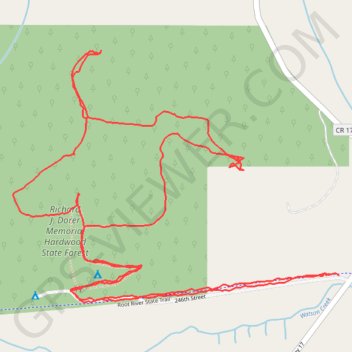
Isinours Forest Management Unit - Richard J. Dorer Memorial Hardwood State Forest Loop
- Distance: 3.3 mi
- Elevation gain: 387 ft
- Maximum elevation: 1,168 ft
- Elevation loss: 381 ft
- Minimum elevation: 906 ft
- Moving time: 1 h 22 m
- Moving speed: 2.4 mph
- Maximum speed: 4.9 mph
- Total time: 2 h 19 m
- Global speed: 1.4 mph
Interactive trail map
Make a donation
Gear up for your next adventure:
As an Amazon Associate, this site earns from qualifying purchases at no extra cost to you.
Trail profile
- Distance: 3.3 mi
- Elevation gain: 387 ft
- Maximum elevation: 1,168 ft
- Elevation loss: 381 ft
- Minimum elevation: 906 ft
- Moving time: 1 h 22 m
- Moving speed: 2.4 mph
- Maximum speed: 4.9 mph
- Total time: 2 h 19 m
- Global speed: 1.4 mph
Make a donation
Gear up for your next adventure:
As an Amazon Associate, this site earns from qualifying purchases at no extra cost to you.
About this trail
Name: Isinours Forest Management Unit - Richard J. Dorer Memorial Hardwood State Forest Loop trail, distance, elevation, map, profile, GPS track
Start: 246th Street, Fillmore County, Minnesota, 55965, United States (43.71084 -92.04947)
End: Root River State Trail, Fillmore County, Minnesota, 55965, United States (43.71087 -92.04978)
Coordinates: 43.71017 -92.06101 43.71661 -92.04947
Topography: Fillmore County topographic map, elevation, terrain
Make a donation
Gear up for your next adventure:
As an Amazon Associate, this site earns from qualifying purchases at no extra cost to you.