Thank you for supporting this site ❤️
Make a donation
Make a donation
Gear up for your next adventure:
As an Amazon Associate, this site earns from qualifying purchases at no extra cost to you.
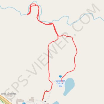
Walk in the forest
- Distance: 0.6 mi
- Elevation gain: 30 ft
- Maximum elevation: 75 ft
- Elevation loss: 43 ft
- Minimum elevation: 33 ft
- Moving time: 19 m 3 s
- Moving speed: 1.9 mph
- Maximum speed: 4.0 mph
- Total time: 23 m 57 s
- Global speed: 1.5 mph
Interactive trail map
Thank you for supporting this site ❤️
Make a donation
Make a donation
Gear up for your next adventure:
As an Amazon Associate, this site earns from qualifying purchases at no extra cost to you.
Trail profile
- Distance: 0.6 mi
- Elevation gain: 30 ft
- Maximum elevation: 75 ft
- Elevation loss: 43 ft
- Minimum elevation: 33 ft
- Moving time: 19 m 3 s
- Moving speed: 1.9 mph
- Maximum speed: 4.0 mph
- Total time: 23 m 57 s
- Global speed: 1.5 mph
Thank you for supporting this site ❤️
Make a donation
Make a donation
Gear up for your next adventure:
As an Amazon Associate, this site earns from qualifying purchases at no extra cost to you.
About this trail
Name: Walk in the forest trail, distance, elevation, map, profile, GPS track
Coordinates: 51.79732 -4.79746 51.80025 -4.79499
Thank you for supporting this site ❤️
Make a donation
Make a donation
Gear up for your next adventure:
As an Amazon Associate, this site earns from qualifying purchases at no extra cost to you.