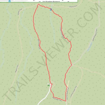
Mica View Trail - Saguaro National Park - Rincon Mountain District
- Distance: 1.9 mi
- Elevation gain: 62 ft
- Maximum elevation: 2,831 ft
- Elevation loss: 62 ft
- Minimum elevation: 2,769 ft
- Moving time: 1 h 10 m
- Moving speed: 1.6 mph
- Maximum speed: 3.6 mph
- Total time: 1 h 26 m
- Global speed: 1.3 mph
Interactive trail map
Trail profile
- Distance: 1.9 mi
- Elevation gain: 62 ft
- Maximum elevation: 2,831 ft
- Elevation loss: 62 ft
- Minimum elevation: 2,769 ft
- Moving time: 1 h 10 m
- Moving speed: 1.6 mph
- Maximum speed: 3.6 mph
- Total time: 1 h 26 m
- Global speed: 1.3 mph
About this trail
Name: Mica View Trail - Saguaro National Park - Rincon Mountain District trail, distance, elevation, map, profile, GPS track
Start: Mica View Trailhead, Mica View, Pima County, Arizona, United States (32.21126 -110.72452)
End: Mica View, Pima County, Arizona, United States (32.21118 -110.72449)
Coordinates: 32.20950 -110.72693 32.22057 -110.72173
Topography: Pima County topographic map, elevation, terrain