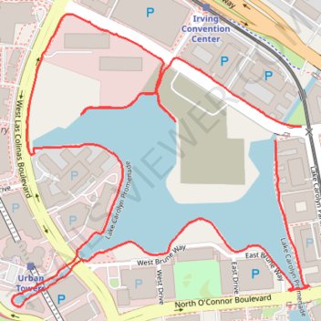
Lake Carolyn Promenade
- Distance: 2.5 mi
- Elevation gain: 95 ft
- Maximum elevation: 446 ft
- Elevation loss: 89 ft
- Minimum elevation: 417 ft
- Moving time: 24 m 33 s
- Moving speed: 6.2 mph
- Maximum speed: 8.9 mph
- Total time: 24 m 33 s
- Global speed: 6.2 mph
Interactive trail map
Trail profile
- Distance: 2.5 mi
- Elevation gain: 95 ft
- Maximum elevation: 446 ft
- Elevation loss: 89 ft
- Minimum elevation: 417 ft
- Moving time: 24 m 33 s
- Moving speed: 6.2 mph
- Maximum speed: 8.9 mph
- Total time: 24 m 33 s
- Global speed: 6.2 mph
About this trail
Name: Lake Carolyn Promenade trail, distance, elevation, map, profile, GPS track
End: Promenade Parkway, Irving, Dallas County, Texas, 75039, United States (32.87416 -96.93590)
Coordinates: 32.86997 -96.94392 32.87678 -96.93569
Topography: Irving topographic map, elevation, terrain
Other hiking, mountain biking, running and outdoor activity trails
Click on a trail to view its statistics, map and profile.
North Texas Trails Initiative Project
United States > Texas > Tarrant County > Grapevine
Distance: 71.6 mi • Elevation gain: 1,545 ft • Maximum elevation: 758 ft