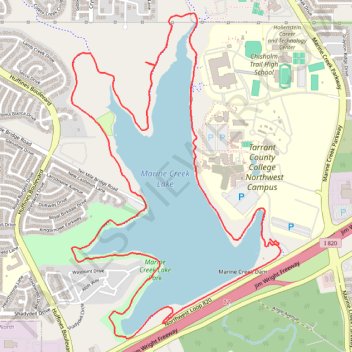
Marine Creek Lake Loop, new sidewalk
- Distance: 6.2 mi
- Elevation gain: 184 ft
- Maximum elevation: 728 ft
- Elevation loss: 180 ft
- Minimum elevation: 692 ft
- Moving time: 1 h 54 m
- Moving speed: 3.3 mph
- Maximum speed: 5.3 mph
- Total time: 1 h 55 m
- Global speed: 3.2 mph
Interactive trail map
Trail profile
- Distance: 6.2 mi
- Elevation gain: 184 ft
- Maximum elevation: 728 ft
- Elevation loss: 180 ft
- Minimum elevation: 692 ft
- Moving time: 1 h 54 m
- Moving speed: 3.3 mph
- Maximum speed: 5.3 mph
- Total time: 1 h 55 m
- Global speed: 3.2 mph
About this trail
Name: Marine Creek Lake Loop, new sidewalk trail, distance, elevation, map, profile, GPS track
Start: TCC Lakeside Drive, Fort Worth, Tarrant County, Texas, 76179, United States (32.82658 -97.38991)
End: TCC Lakeside Drive, Fort Worth, Tarrant County, Texas, 76179, United States (32.82678 -97.38985)
Coordinates: 32.82034 -97.40513 32.84143 -97.38902
Topography: Fort Worth topographic map, elevation, terrain