Make a donation
Gear up for your next adventure:
As an Amazon Associate, this site earns from qualifying purchases at no extra cost to you.
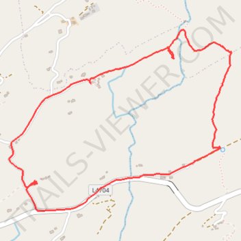
Farranamanagh Loop Walk
- Distance: 2.3 mi
- Elevation gain: 236 ft
- Maximum elevation: 269 ft
- Elevation loss: 233 ft
- Minimum elevation: 79 ft
- Moving time: 1 h 14 m
- Moving speed: 1.8 mph
- Maximum speed: 4.0 mph
- Total time: 1 h 37 m
- Global speed: 1.4 mph
Interactive trail map
Make a donation
Gear up for your next adventure:
As an Amazon Associate, this site earns from qualifying purchases at no extra cost to you.
Trail profile
- Distance: 2.3 mi
- Elevation gain: 236 ft
- Maximum elevation: 269 ft
- Elevation loss: 233 ft
- Minimum elevation: 79 ft
- Moving time: 1 h 14 m
- Moving speed: 1.8 mph
- Maximum speed: 4.0 mph
- Total time: 1 h 37 m
- Global speed: 1.4 mph
Make a donation
Gear up for your next adventure:
As an Amazon Associate, this site earns from qualifying purchases at no extra cost to you.
About this trail
Name: Farranamanagh Loop Walk trail, distance, elevation, map, profile, GPS track
Start: Seefin, West Cork, County Cork, Munster, Ireland (51.58473 -9.69225)
End: Seefin, West Cork, County Cork, Munster, Ireland (51.58476 -9.69255)
Coordinates: 51.58353 -9.69428 51.59147 -9.67858
Make a donation
Gear up for your next adventure:
As an Amazon Associate, this site earns from qualifying purchases at no extra cost to you.
Other hiking, mountain biking, running and outdoor activity trails
Click on a trail to view its statistics, map and profile.
Old road from Kilcrohane to Ahakista
Distance: 3.7 mi • Elevation gain: 305 ft • Maximum elevation: 292 ft