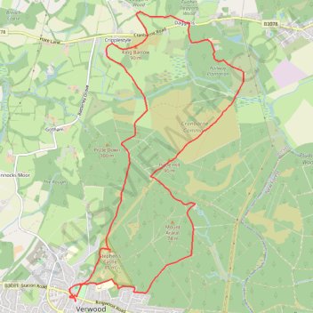
King Barrow Loop hike from Verwood
- Distance: 7.7 mi
- Elevation gain: 518 ft
- Maximum elevation: 325 ft
- Elevation loss: 518 ft
- Minimum elevation: 138 ft
- Moving time: 2 h 36 m
- Moving speed: 2.9 mph
- Maximum speed: 3.4 mph
- Total time: 2 h 36 m
- Global speed: 2.9 mph
Interactive trail map
Trail profile
- Distance: 7.7 mi
- Elevation gain: 518 ft
- Maximum elevation: 325 ft
- Elevation loss: 518 ft
- Minimum elevation: 138 ft
- Moving time: 2 h 36 m
- Moving speed: 2.9 mph
- Maximum speed: 3.4 mph
- Total time: 2 h 36 m
- Global speed: 2.9 mph
About this trail
Name: King Barrow Loop hike from Verwood trail, distance, elevation, map, profile, GPS track
Start: Potters Wheel, Howard Road, Verwood, Dorset, England, BH31 6ND, United Kingdom (50.88093 -1.87795)
End: Potters Wheel, Howard Road, Verwood, Dorset, England, BH31 6ND, United Kingdom (50.88093 -1.87793)
Coordinates: 50.88093 -1.87905 50.91350 -1.84798