Make a donation
Gear up for your next adventure:
As an Amazon Associate, this site earns from qualifying purchases at no extra cost to you.
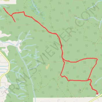
Port Gamble Forest Heritage Park
- Distance: 5.2 mi
- Elevation gain: 430 ft
- Maximum elevation: 489 ft
- Elevation loss: 427 ft
- Minimum elevation: 259 ft
- Moving time: 37 m 34 s
- Moving speed: 8.4 mph
- Maximum speed: 17.0 mph
- Total time: 38 m 34 s
- Global speed: 8.1 mph
Interactive trail map
Make a donation
Gear up for your next adventure:
As an Amazon Associate, this site earns from qualifying purchases at no extra cost to you.
Trail profile
- Distance: 5.2 mi
- Elevation gain: 430 ft
- Maximum elevation: 489 ft
- Elevation loss: 427 ft
- Minimum elevation: 259 ft
- Moving time: 37 m 34 s
- Moving speed: 8.4 mph
- Maximum speed: 17.0 mph
- Total time: 38 m 34 s
- Global speed: 8.1 mph
Make a donation
Gear up for your next adventure:
As an Amazon Associate, this site earns from qualifying purchases at no extra cost to you.
About this trail
Name: Port Gamble Forest Heritage Park trail, distance, elevation, map, profile, GPS track
Start: Stottlemeyer Road Northeast, Kitsap County, Washington, United States (47.78857 -122.59660)
End: Stottlemeyer Road Northeast, Kitsap County, Washington, United States (47.78863 -122.59659)
Coordinates: 47.78857 -122.62653 47.80694 -122.59659
Topography: Kitsap County topographic map, elevation, terrain
Make a donation
Gear up for your next adventure:
As an Amazon Associate, this site earns from qualifying purchases at no extra cost to you.