元墩山
Outdoor hiking
- Distance: 0.5 mi
- Elevation gain: 16 ft
- Maximum elevation: 26 ft
- Elevation loss: 13 ft
- Minimum elevation: 7 ft
- Moving time: 15 m
- Moving speed: 2.1 mph
- Maximum speed: 4.4 mph
- Total time: 24 m 4 s
- Global speed: 1.3 mph
Interactive trail map
Trail profile
- Distance: 0.5 mi
- Elevation gain: 16 ft
- Maximum elevation: 26 ft
- Elevation loss: 13 ft
- Minimum elevation: 7 ft
- Moving time: 15 m
- Moving speed: 2.1 mph
- Maximum speed: 4.4 mph
- Total time: 24 m 4 s
- Global speed: 1.3 mph
About this trail
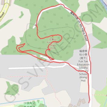
Name: 元墩山 trail, distance, elevation, map, profile, GPS track
Coordinates: 22.54697 114.22381 22.54899 114.22545