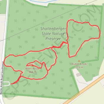
Shallenberger Park Trails
- Distance: 1.6 mi
- Elevation gain: 292 ft
- Maximum elevation: 1,099 ft
- Elevation loss: 289 ft
- Minimum elevation: 932 ft
- Moving time: 29 m 58 s
- Moving speed: 3.2 mph
- Maximum speed: 8.3 mph
- Total time: 29 m 58 s
- Global speed: 3.2 mph
Interactive trail map
Trail profile
- Distance: 1.6 mi
- Elevation gain: 292 ft
- Maximum elevation: 1,099 ft
- Elevation loss: 289 ft
- Minimum elevation: 932 ft
- Moving time: 29 m 58 s
- Moving speed: 3.2 mph
- Maximum speed: 8.3 mph
- Total time: 29 m 58 s
- Global speed: 3.2 mph
About this trail
Name: Shallenberger Park Trails trail, distance, elevation, map, profile, GPS track
Coordinates: 39.69146 -82.65763 39.69528 -82.65021
Topography: Lancaster topographic map, elevation, terrain