Thank you for supporting this site ❤️
Make a donation
Make a donation
Gear up for your next adventure:
As an Amazon Associate, this site earns from qualifying purchases at no extra cost to you.
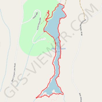
Bear canyon lake loop
- Distance: 3.7 mi
- Elevation gain: 515 ft
- Maximum elevation: 7,667 ft
- Elevation loss: 518 ft
- Minimum elevation: 7,559 ft
- Moving time: 1 h 44 m
- Moving speed: 2.2 mph
- Maximum speed: 5.7 mph
- Total time: 1 h 56 m
- Global speed: 1.9 mph
Interactive trail map
Thank you for supporting this site ❤️
Make a donation
Make a donation
Gear up for your next adventure:
As an Amazon Associate, this site earns from qualifying purchases at no extra cost to you.
Trail profile
- Distance: 3.7 mi
- Elevation gain: 515 ft
- Maximum elevation: 7,667 ft
- Elevation loss: 518 ft
- Minimum elevation: 7,559 ft
- Moving time: 1 h 44 m
- Moving speed: 2.2 mph
- Maximum speed: 5.7 mph
- Total time: 1 h 56 m
- Global speed: 1.9 mph
Thank you for supporting this site ❤️
Make a donation
Make a donation
Gear up for your next adventure:
As an Amazon Associate, this site earns from qualifying purchases at no extra cost to you.
About this trail
Name: Bear canyon lake loop trail, distance, elevation, map, profile, GPS track
Start: Mallard, Coconino County, Arizona, United States (34.40544 -111.00439)
End: Mallard, Coconino County, Arizona, United States (34.40560 -111.00424)
Coordinates: 34.39102 -111.00682 34.40701 -111.00054
Topography: Coconino County topographic map, elevation, terrain
Thank you for supporting this site ❤️
Make a donation
Make a donation
Gear up for your next adventure:
As an Amazon Associate, this site earns from qualifying purchases at no extra cost to you.