Make a donation
Gear up for your next adventure:
As an Amazon Associate, this site earns from qualifying purchases at no extra cost to you.
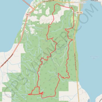
Port Gamble Forest Heritage Park Loop MTB
- Distance: 10.4 mi
- Elevation gain: 958 ft
- Maximum elevation: 469 ft
- Elevation loss: 958 ft
- Minimum elevation: 39 ft
- Moving time: 1 h 59 m
- Moving speed: 5.2 mph
- Maximum speed: 22.1 mph
- Total time: 2 h 15 m
- Global speed: 4.6 mph
Interactive trail map
Make a donation
Gear up for your next adventure:
As an Amazon Associate, this site earns from qualifying purchases at no extra cost to you.
Trail profile
- Distance: 10.4 mi
- Elevation gain: 958 ft
- Maximum elevation: 469 ft
- Elevation loss: 958 ft
- Minimum elevation: 39 ft
- Moving time: 1 h 59 m
- Moving speed: 5.2 mph
- Maximum speed: 22.1 mph
- Total time: 2 h 15 m
- Global speed: 4.6 mph
Make a donation
Gear up for your next adventure:
As an Amazon Associate, this site earns from qualifying purchases at no extra cost to you.
About this trail
Name: Port Gamble Forest Heritage Park Loop MTB trail, distance, elevation, map, profile, GPS track
Coordinates: 47.81790 -122.61307 47.85365 -122.58720
Topography: Kitsap County topographic map, elevation, terrain
Make a donation
Gear up for your next adventure:
As an Amazon Associate, this site earns from qualifying purchases at no extra cost to you.
Other hiking, mountain biking, running and outdoor activity trails
Click on a trail to view its statistics, map and profile.
Port Gamble Forest Heritage Park Mountain Biking
United States > Washington > Kitsap County > Port Gamble
Distance: 14.9 mi • Elevation gain: 1,867 ft • Maximum elevation: 472 ft