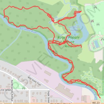
Roger Popple Nature Area trails
Reedsburg, trails, hiking
- Distance: 2.5 mi
- Elevation gain: 49 ft
- Maximum elevation: 889 ft
- Elevation loss: 49 ft
- Minimum elevation: 873 ft
- Moving time: 51 m 24 s
- Moving speed: 2.9 mph
- Maximum speed: 6.3 mph
- Total time: 1 h 5 m
- Global speed: 2.3 mph
Interactive trail map
Trail profile
- Distance: 2.5 mi
- Elevation gain: 49 ft
- Maximum elevation: 889 ft
- Elevation loss: 49 ft
- Minimum elevation: 873 ft
- Moving time: 51 m 24 s
- Moving speed: 2.9 mph
- Maximum speed: 6.3 mph
- Total time: 1 h 5 m
- Global speed: 2.3 mph
About this trail
Name: Roger Popple Nature Area trails trail, distance, elevation, map, profile, GPS track
Start: Entry Trail, Reedsburg, Sauk County, Wisconsin, 53959, United States (43.53602 -90.01266)
End: Entry Trail, Reedsburg, Sauk County, Wisconsin, 53959, United States (43.53614 -90.01280)
Coordinates: 43.53289 -90.01929 43.53862 -90.01103
Topography: Sauk County topographic map, elevation, terrain