Make a donation
Gear up for your next adventure:
As an Amazon Associate, this site earns from qualifying purchases at no extra cost to you.
West Fork Trail in Coconino National Forest
The West Fork Trail is a captivating hike that offers a blend of scenic beauty and natural history. The trail meanders along the West Fork of Oak Creek, providing stunning views of the red rock cliffs, dense forests of Douglas firs, and vibrant riparian flora. Throughout the route, hikers will encounter several creek crossings, some requiring agility to keep feet dry, and witness diverse wildlife such as mule deer and Abert's squirrels. The trail is popular but rewarding, with both accessible sections and more secluded areas that bring a sense of tranquility as you venture deeper into the canyon. #Hiking #Canyon #Forest #Nature #River #Rock #Cliff
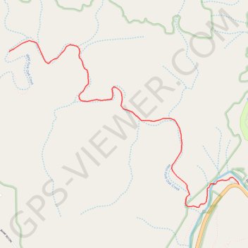
- Distance: 6.0 mi
- Elevation gain: 1,070 ft
- Maximum elevation: 5,696 ft
- Elevation loss: 1,040 ft
- Minimum elevation: 5,308 ft
Interactive trail map
Make a donation
Gear up for your next adventure:
As an Amazon Associate, this site earns from qualifying purchases at no extra cost to you.
Trail profile
- Distance: 6.0 mi
- Elevation gain: 1,070 ft
- Maximum elevation: 5,696 ft
- Elevation loss: 1,040 ft
- Minimum elevation: 5,308 ft
Make a donation
Gear up for your next adventure:
As an Amazon Associate, this site earns from qualifying purchases at no extra cost to you.
About this trail
Name: West Fork Trail in Coconino National Forest trail, distance, elevation, map, profile, GPS track
Start: West Fork Trail, Coconino County, Arizona, United States (34.99065 -111.74377)
End: Shady Lane, Coconino County, Arizona, United States (34.99026 -111.74169)
Coordinates: 34.98802 -111.76885 35.00420 -111.74169
Topography: Coconino County topographic map, elevation, terrain
Make a donation
Gear up for your next adventure:
As an Amazon Associate, this site earns from qualifying purchases at no extra cost to you.
Other hiking, mountain biking, running and outdoor activity trails
Click on a trail to view its statistics, map and profile.
West Fork Trail along West Fork Oak Creek in Red Rock-Secret Mountain Wilderness
United States > Arizona > Coconino County
The West Fork Trail is a gem for hikers looking to escape the Arizona sun, as the towering canyon walls and lush tree cover create a cool and inviting atmosphere. Following the creek, you'll navigate delightful stream crossings that add a fun challenge while being rewarded with stunning views of red rock…
Distance: 7.2 mi • Elevation gain: 1,529 ft • Maximum elevation: 5,764 ft