Mount Islip via Pacific Crest Trail / Silver Moccasin Trail and Mount Islip Trail
Hiking Mount Islip offers a well-rounded experience in the San Gabriel Mountains. Along the route, you'll encounter diverse landscapes, including dense forests, scenic ridgelines, and expansive views stretching from the Mojave Desert to the surrounding San Gabriel Canyon, with glimpses of the rugged ridges and distant peaks. The trail also passes historical remnants, such as the old fire tower foundations, and offers a glimpse into the area's post-fire recovery, with occasional evidence of the 2002 Curve Fire. The journey is serene, with opportunities to spot wildlife, including big horn sheep, and enjoy sweeping vistas as you ascend to the summit. #Hiking #Mountain #Forest #Nature #PCT
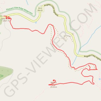
- Distance: 5.5 mi
- Elevation gain: 2,438 ft
- Maximum elevation: 8,222 ft
- Elevation loss: 892 ft
- Minimum elevation: 6,670 ft
Interactive trail map
Trail profile
- Distance: 5.5 mi
- Elevation gain: 2,438 ft
- Maximum elevation: 8,222 ft
- Elevation loss: 892 ft
- Minimum elevation: 6,670 ft
About this trail
Name: Mount Islip via Pacific Crest Trail / Silver Moccasin Trail and Mount Islip Trail trail, distance, elevation, map, profile, GPS track
End: Mount Islip Trail, Los Angeles County, California, United States (34.34509 -117.83985)
Coordinates: 34.34423 -117.85117 34.35706 -117.83012
Topography: Los Angeles County topographic map, elevation, terrain
Other hiking, mountain biking, running and outdoor activity trails
Click on a trail to view its statistics, map and profile.