Make a donation
Gear up for your next adventure:
As an Amazon Associate, this site earns from qualifying purchases at no extra cost to you.
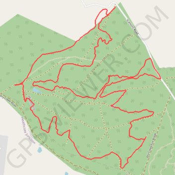
Wandong loop
- Distance: 6.9 mi
- Elevation gain: 1,401 ft
- Maximum elevation: 1,552 ft
- Elevation loss: 1,401 ft
- Minimum elevation: 1,119 ft
- Moving time: 50 m 29 s
- Moving speed: 8.2 mph
- Maximum speed: 25.9 mph
- Total time: 1 h 6 m
- Global speed: 6.2 mph
Interactive trail map
Make a donation
Gear up for your next adventure:
As an Amazon Associate, this site earns from qualifying purchases at no extra cost to you.
Trail profile
- Distance: 6.9 mi
- Elevation gain: 1,401 ft
- Maximum elevation: 1,552 ft
- Elevation loss: 1,401 ft
- Minimum elevation: 1,119 ft
- Moving time: 50 m 29 s
- Moving speed: 8.2 mph
- Maximum speed: 25.9 mph
- Total time: 1 h 6 m
- Global speed: 6.2 mph
Make a donation
Gear up for your next adventure:
As an Amazon Associate, this site earns from qualifying purchases at no extra cost to you.
About this trail
Name: Wandong loop trail, distance, elevation, map, profile, GPS track
Start: Scanlons Road, Wandong, Shire of Mitchell, Victoria, 3758, Australia (-37.35437 145.05639)
End: Scanlons Road, Wandong, Shire of Mitchell, Victoria, 3758, Australia (-37.35366 145.05714)
Coordinates: -37.36991 145.04438 -37.35366 145.06288
Make a donation
Gear up for your next adventure:
As an Amazon Associate, this site earns from qualifying purchases at no extra cost to you.
Other hiking, mountain biking, running and outdoor activity trails
Click on a trail to view its statistics, map and profile.
Tallarook - Eildon - Hurstbridge
Australia > Victoria > Tallarook
#Bike
Distance: 173.2 mi • Elevation gain: 16,066 ft • Maximum elevation: 2,848 ft