Spruce Nature Trail and Hall of Mosses Trail Loop in Olympic National Park
The Spruce Nature Trail and Hall of Mosses Trail Loop in Olympic National Park offers a delightful journey through one of the finest examples of temperate rainforest in the U.S. As you wander along the well-maintained paths, you'll be surrounded by towering old-growth trees draped in vibrant mosses, creating a serene, otherworldly atmosphere, with occasional glimpses of the sparkling Hoh River and verdant meadows. The loop features fascinating natural elements such as lush ferns, fern-covered fallen logs that act as nurseries for new plants, and the iconic moss-draped arches that make this area so unique. #Hiking #Loop #Forest #Nature
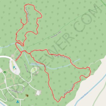
- Distance: 2.2 mi
- Elevation gain: 220 ft
- Maximum elevation: 722 ft
- Elevation loss: 220 ft
- Minimum elevation: 594 ft
- Moving time: 1 h 10 m
- Moving speed: 1.9 mph
- Maximum speed: 5.5 mph
- Total time: 1 h 18 m
- Global speed: 1.7 mph
Interactive trail map
Trail profile
- Distance: 2.2 mi
- Elevation gain: 220 ft
- Maximum elevation: 722 ft
- Elevation loss: 220 ft
- Minimum elevation: 594 ft
- Moving time: 1 h 10 m
- Moving speed: 1.9 mph
- Maximum speed: 5.5 mph
- Total time: 1 h 18 m
- Global speed: 1.7 mph
About this trail
Name: Spruce Nature Trail and Hall of Mosses Trail Loop in Olympic National Park trail, distance, elevation, map, profile, GPS track
Start: Mini Trail, Jefferson County, Washington, United States (47.86046 -123.93440)
End: Mini Trail, Jefferson County, Washington, United States (47.86045 -123.93442)
Coordinates: 47.85732 -123.93444 47.86476 -123.92594
Topography: Jefferson County topographic map, elevation, terrain
Other hiking, mountain biking, running and outdoor activity trails
Click on a trail to view its statistics, map and profile.
Mineral Creek Falls via Hoh River Trail in Olympic National Park
United States > Washington > Jefferson County
The Hoh River Trail to Mineral Creek Falls offers hikers a serene journey through the lush, moss-draped rainforest of Olympic National Park. Along the way, the trail meanders beside the glacial blue Hoh River, providing tranquil views of its clear waters. Upon reaching Mineral Creek Falls, hikers are treated…
Distance: 5.5 mi • Elevation gain: 804 ft • Maximum elevation: 797 ft