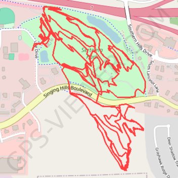
Almost all the Mountain Bike trails at Cone Park
- Distance: 13.2 mi
- Elevation gain: 1,532 ft
- Maximum elevation: 1,283 ft
- Elevation loss: 1,532 ft
- Minimum elevation: 1,089 ft
- Moving time: 1 h 31 m
- Moving speed: 8.7 mph
- Maximum speed: 23.5 mph
- Total time: 1 h 51 m
- Global speed: 7.1 mph
Interactive trail map
Trail profile
- Distance: 13.2 mi
- Elevation gain: 1,532 ft
- Maximum elevation: 1,283 ft
- Elevation loss: 1,532 ft
- Minimum elevation: 1,089 ft
- Moving time: 1 h 31 m
- Moving speed: 8.7 mph
- Maximum speed: 23.5 mph
- Total time: 1 h 51 m
- Global speed: 7.1 mph
About this trail
Name: Almost all the Mountain Bike trails at Cone Park trail, distance, elevation, map, profile, GPS track
Start: Line Drive, Sioux City, Woodbury County, Iowa, 51106, United States (42.44119 -96.36131)
End: Line Drive, Sioux City, Woodbury County, Iowa, 51106, United States (42.44117 -96.36134)
Coordinates: 42.43316 -96.36134 42.44406 -96.35118
Topography: Sioux City topographic map, elevation, terrain