Company Mill Loop Trail in William B. Umstead State Park
The Company Mill Loop Trail weaves through picturesque hardwood forests, hugging the banks of Crabtree Creek before ascending into quiet ridges. Hikers can enjoy a blend of open creekside views, where remnants of an old mill create a peaceful spot to rest, and more secluded sections under a canopy of pines and oaks. This trail’s varied terrain and serene water features make it a popular choice for those seeking both a moderate workout and moments of calm within reach of the city. #Hiking #Loop #River #Forest #Nature
- Distance: 6.2 mi
- Elevation gain: 600 ft
- Maximum elevation: 469 ft
- Elevation loss: 577 ft
- Minimum elevation: 272 ft
- Moving time: 2 h 29 m
- Moving speed: 2.5 mph
- Maximum speed: 5.2 mph
- Total time: 2 h 31 m
- Global speed: 2.5 mph
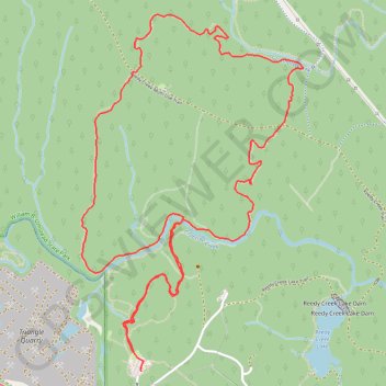
Interactive trail map
Trail profile
- Distance: 6.2 mi
- Elevation gain: 600 ft
- Maximum elevation: 469 ft
- Elevation loss: 577 ft
- Minimum elevation: 272 ft
- Moving time: 2 h 29 m
- Moving speed: 2.5 mph
- Maximum speed: 5.2 mph
- Total time: 2 h 31 m
- Global speed: 2.5 mph
About this trail
Name: Company Mill Loop Trail in William B. Umstead State Park trail, distance, elevation, map, profile, GPS track
Start: Company Mill Trail, Raleigh, Wake County, North Carolina, United States (35.83685 -78.76013)
End: Company Mill Trail, Raleigh, Wake County, North Carolina, United States (35.83571 -78.75960)
Coordinates: 35.83571 -78.76397 35.85697 -78.74763
Topography: Raleigh topographic map, elevation, terrain
Other hiking, mountain biking, running and outdoor activity trails
Click on a trail to view its statistics, map and profile.
Sycamore and Graylyn Loop at Umstead Park
United States > North Carolina > Wake County > Raleigh
Distance: 3.2 mi • Elevation gain: 279 ft • Maximum elevation: 469 ft