Double Arch Loop via Auxier Ridge, Haystack Rock and Courthouse Rock
The Double Arch Loop offers hikers a memorable journey through some of the region's most striking natural features. As you traverse the Auxier Ridge, expect to be treated to sweeping views of the Red River Gorge, with expansive vistas over rocky outcrops, lush valleys, and iconic rock formations like Double Arch, Courthouse Rock, and Haystack Rock. The trail winds through a mixture of forested paths, exposed ridges, and overlooks, with the added excitement of scrambling up to the impressive Double Arch and exploring its surrounding geological wonders. #Hiking #Loop #Arch #Rock #Gorge #Overlook #Forest #Nature
- Distance: 6.2 mi
- Elevation gain: 1,007 ft
- Maximum elevation: 1,296 ft
- Elevation loss: 1,007 ft
- Minimum elevation: 856 ft
- Moving time: 2 h 46 m
- Moving speed: 2.2 mph
- Maximum speed: 5.4 mph
- Total time: 2 h 57 m
- Global speed: 2.1 mph
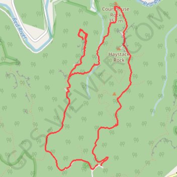
Interactive trail map
Trail profile
- Distance: 6.2 mi
- Elevation gain: 1,007 ft
- Maximum elevation: 1,296 ft
- Elevation loss: 1,007 ft
- Minimum elevation: 856 ft
- Moving time: 2 h 46 m
- Moving speed: 2.2 mph
- Maximum speed: 5.4 mph
- Total time: 2 h 57 m
- Global speed: 2.1 mph
About this trail
Name: Double Arch Loop via Auxier Ridge, Haystack Rock and Courthouse Rock trail, distance, elevation, map, profile, GPS track
Start: Auxier Ridge Trail #204, Powell County, Kentucky, 40376, United States (37.82017 -83.68093)
End: Tunnel Ridge Road, Powell County, Kentucky, 40376, United States (37.82031 -83.68155)
Coordinates: 37.81955 -83.69057 37.84187 -83.67576
Topography: Powell County topographic map, elevation, terrain
Other hiking, mountain biking, running and outdoor activity trails
Click on a trail to view its statistics, map and profile.
Double Arch, Courthouse Rock, Haystack Rock and Auxier Ridge Loop
United States > Kentucky > Powell County
From the Auxier Ridge trailhead, the loop first slips into forest on the Double Arch side, passing sandstone walls, hemlocks and magnolias before reaching the broad overlook beneath Double Arch, with views opening toward the rock country of Red River Gorge. The route then links through Auxier Branch, where…
Distance: 6.1 mi • Elevation gain: 942 ft • Maximum elevation: 1,296 ft
Courthouse Rock via Auxier Ridge Trail in Red River Gorge Geological Area
United States > Kentucky > Powell County
The Auxier Ridge Trail offers a rewarding hike with breathtaking panoramic views, especially as it climbs the narrow ridge toward Courthouse Rock. Along the way, hikers will encounter striking geological features like Haystack Rock and Wizard's Backbone, while experiencing varied landscapes that include lush…
Distance: 4.3 mi • Elevation gain: 840 ft • Maximum elevation: 1,283 ft
Auxier Ridge, Haystack Rock, Courthouse Rock and Double Arch Loop
United States > Kentucky > Powell County
The Auxier Ridge, Haystack Rock, Courthouse Rock, and Double Arch Loop in Kentucky's Daniel Boone National Forest offers hikers a diverse and scenic experience. Along the trail, you'll encounter Haystack Rock, a prominent sandstone formation; Courthouse Rock, a towering cliff resembling a courthouse; and the…
Distance: 6.4 mi • Elevation gain: 1,040 ft • Maximum elevation: 1,296 ft