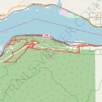
CLIMB trails network in Cascade Locks, Oregon
- Distance: 18.4 mi
- Elevation gain: 3,317 ft
- Maximum elevation: 1,050 ft
- Elevation loss: 3,304 ft
- Minimum elevation: 112 ft
- Moving time: 2 h 6 m
- Moving speed: 8.8 mph
- Maximum speed: 27.6 mph
- Total time: 2 h 15 m
- Global speed: 8.2 mph
Interactive trail map
Trail profile
- Distance: 18.4 mi
- Elevation gain: 3,317 ft
- Maximum elevation: 1,050 ft
- Elevation loss: 3,304 ft
- Minimum elevation: 112 ft
- Moving time: 2 h 6 m
- Moving speed: 8.8 mph
- Maximum speed: 27.6 mph
- Total time: 2 h 15 m
- Global speed: 8.2 mph
About this trail
Name: CLIMB trails network in Cascade Locks, Oregon trail, distance, elevation, map, profile, GPS track
Coordinates: 45.67980 -121.84014 45.69468 -121.75494
Topography: Hood River County topographic map, elevation, terrain
Other hiking, mountain biking, running and outdoor activity trails
Click on a trail to view its statistics, map and profile.
Northern part of the Pacific Crest Trail (PCT)
United States > Oregon > Klamath County
Hike on the Pacific Crest National Scenic Trail from Crater Lake to Canada Border through Oregon and Washington along the Sierra Nevada and Cascade mountain ranges. #Hiking #Mountain #SierraNevada #Cascade #Nature #Forest #Park #PCT
Distance: 744.6 mi • Elevation gain: 145,367 ft • Maximum elevation: 7,569 ft