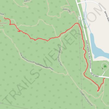
Pine Mountain South Approach B
- Distance: 1.2 mi
- Elevation gain: 627 ft
- Maximum elevation: 1,486 ft
- Elevation loss: 46 ft
- Minimum elevation: 889 ft
- Moving time: 37 m 30 s
- Moving speed: 2.0 mph
- Maximum speed: 4.0 mph
- Total time: 42 m 54 s
- Global speed: 1.7 mph
Interactive trail map
Trail profile
- Distance: 1.2 mi
- Elevation gain: 627 ft
- Maximum elevation: 1,486 ft
- Elevation loss: 46 ft
- Minimum elevation: 889 ft
- Moving time: 37 m 30 s
- Moving speed: 2.0 mph
- Maximum speed: 4.0 mph
- Total time: 42 m 54 s
- Global speed: 1.7 mph
About this trail
Name: Pine Mountain South Approach B trail, distance, elevation, map, profile, GPS track
Start: Connector, Bartow County, Georgia, United States (34.17156 -84.73431)
Coordinates: 34.17041 -84.74480 34.17676 -84.73431
Topography: Bartow County topographic map, elevation, terrain