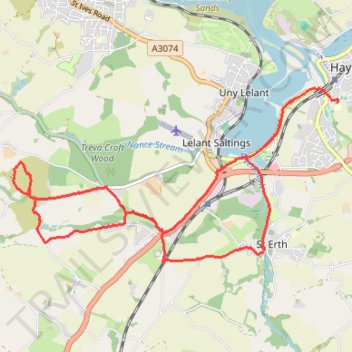
Hike to Trencrom
- Distance: 8.7 mi
- Elevation gain: 732 ft
- Maximum elevation: 561 ft
- Elevation loss: 705 ft
- Minimum elevation: -3 ft
- Moving time: 3 h 29 m
- Moving speed: 2.5 mph
- Maximum speed: 4.6 mph
- Total time: 4 h 9 m
- Global speed: 2.1 mph
Interactive trail map
Trail profile
- Distance: 8.7 mi
- Elevation gain: 732 ft
- Maximum elevation: 561 ft
- Elevation loss: 705 ft
- Minimum elevation: -3 ft
- Moving time: 3 h 29 m
- Moving speed: 2.5 mph
- Maximum speed: 4.6 mph
- Total time: 4 h 9 m
- Global speed: 2.1 mph
About this trail
Name: Hike to Trencrom trail, distance, elevation, map, profile, GPS track
Start: Carnsew Road, Hayle, Cornwall, England, TR27 6JE, United Kingdom (50.18070 -5.43007)
Coordinates: 50.16340 -5.48067 50.18447 -5.41915
Other hiking, mountain biking, running and outdoor activity trails
Click on a trail to view its statistics, map and profile.
Lelant Saltings to Loggan's Moor
United Kingdom > England > Cornwall > St. Ives > Lelant Saltings
Distance: 6.6 mi • Elevation gain: 207 ft • Maximum elevation: 39 ft
Hayle to Godrevy Point
United Kingdom > England > Cornwall > Hayle > Phillack
Distance: 13.5 mi • Elevation gain: 1,234 ft • Maximum elevation: 200 ft
St Ives to Hayle
United Kingdom > England > Cornwall > St. Ives
Distance: 10.7 mi • Elevation gain: 1,549 ft • Maximum elevation: 197 ft
Run around Hayle
United Kingdom > England > Cornwall > St. Ives > Lelant Saltings
Distance: 6.4 mi • Elevation gain: 194 ft • Maximum elevation: 39 ft