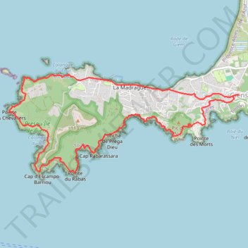
PRESQU'ILE DE GIENS
- Distance: 6.6 mi
- Elevation gain: 1,670 ft
- Maximum elevation: 276 ft
- Elevation loss: 1,667 ft
- Minimum elevation: -3 ft
- Moving time: 3 h 30 m
- Moving speed: 1.9 mph
- Maximum speed: 2.3 mph
- Total time: 3 h 30 m
- Global speed: 1.9 mph
Interactive trail map
Trail profile
- Distance: 6.6 mi
- Elevation gain: 1,670 ft
- Maximum elevation: 276 ft
- Elevation loss: 1,667 ft
- Minimum elevation: -3 ft
- Moving time: 3 h 30 m
- Moving speed: 1.9 mph
- Maximum speed: 2.3 mph
- Total time: 3 h 30 m
- Global speed: 1.9 mph
About this trail
Name: PRESQU'ILE DE GIENS trail, distance, elevation, map, profile, GPS track
Coordinates: 43.02815 6.09159 43.04076 6.13181
Other hiking, mountain biking, running and outdoor activity trails
Click on a trail to view its statistics, map and profile.
1 LUCENA - MONTPELLIER
Distance: 1,842.0 mi • Elevation gain: 96,785 ft • Maximum elevation: 3,438 ft
PT23DS2 Lörrach → Cadaqués
Germany > Baden-Württemberg > Landkreis Lörrach > Lörrach (Kernstadt)
Distance: 652.9 mi • Elevation gain: 43,077 ft • Maximum elevation: 4,938 ft
Chemin de Saint-Jacques-de-Compostelle
Switzerland > Geneva > Geneva
Distance: 694.6 mi • Elevation gain: 82,881 ft • Maximum elevation: 4,692 ft