Thank you for supporting this site ❤️
Make a donation
Make a donation
Gear up for your next adventure:
As an Amazon Associate, this site earns from qualifying purchases at no extra cost to you.
Mountain Bike trail, Honey Trails
Bicycle Tour
- Distance: 8.6 mi
- Elevation gain: 1,122 ft
- Maximum elevation: 2,723 ft
- Elevation loss: 1,125 ft
- Minimum elevation: 2,310 ft
- Moving time: 52 m 21 s
- Moving speed: 9.8 mph
- Maximum speed: 25.2 mph
- Total time: 1 h 3 m
- Global speed: 8.2 mph
Interactive trail map
Thank you for supporting this site ❤️
Make a donation
Make a donation
Gear up for your next adventure:
As an Amazon Associate, this site earns from qualifying purchases at no extra cost to you.
Trail profile
- Distance: 8.6 mi
- Elevation gain: 1,122 ft
- Maximum elevation: 2,723 ft
- Elevation loss: 1,125 ft
- Minimum elevation: 2,310 ft
- Moving time: 52 m 21 s
- Moving speed: 9.8 mph
- Maximum speed: 25.2 mph
- Total time: 1 h 3 m
- Global speed: 8.2 mph
Thank you for supporting this site ❤️
Make a donation
Make a donation
Gear up for your next adventure:
As an Amazon Associate, this site earns from qualifying purchases at no extra cost to you.
About this trail
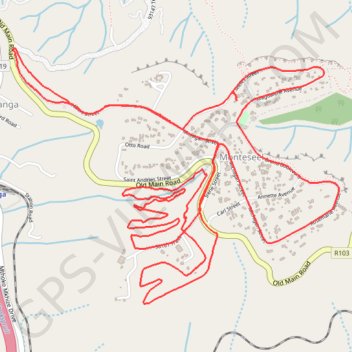
Name: Mountain Bike trail, Honey Trails trail, distance, elevation, map, profile, GPS track
Coordinates: -29.74903 30.66516 -29.73431 30.68675
Thank you for supporting this site ❤️
Make a donation
Make a donation
Gear up for your next adventure:
As an Amazon Associate, this site earns from qualifying purchases at no extra cost to you.