Baunton Cirencester
- Distance: 14.5 mi
- Elevation gain: 594 ft
- Maximum elevation: 571 ft
- Elevation loss: 594 ft
- Minimum elevation: 344 ft
- Moving time: 4 h 21 m
- Moving speed: 3.3 mph
- Maximum speed: 18.2 mph
- Total time: 5 h 46 m
- Global speed: 2.5 mph
Interactive trail map
Trail profile
- Distance: 14.5 mi
- Elevation gain: 594 ft
- Maximum elevation: 571 ft
- Elevation loss: 594 ft
- Minimum elevation: 344 ft
- Moving time: 4 h 21 m
- Moving speed: 3.3 mph
- Maximum speed: 18.2 mph
- Total time: 5 h 46 m
- Global speed: 2.5 mph
About this trail
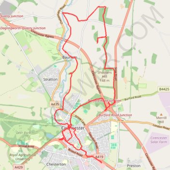
Name: Baunton Cirencester trail, distance, elevation, map, profile, GPS track
Coordinates: 51.70581 -1.97559 51.75519 -1.94449
Other hiking, mountain biking, running and outdoor activity trails
Click on a trail to view its statistics, map and profile.
Cirencester, Baunton and Shooters Hill Loop
United Kingdom > England > Gloucestershire > Cotswold District > Cirencester > Chesterton
Distance: 9.3 mi • Elevation gain: 433 ft • Maximum elevation: 571 ft
Cirencester Dobbies
United Kingdom > England > Gloucestershire > Cotswold District > Cirencester > Chesterton
Distance: 6.1 mi • Elevation gain: 148 ft • Maximum elevation: 384 ft
Ciren Park Loop
United Kingdom > England > Gloucestershire > Cotswold District > Cirencester > Chesterton
Distance: 14.6 mi • Elevation gain: 577 ft • Maximum elevation: 600 ft
Dean2023-311
United Kingdom > England > Oxfordshire > Oxford
Distance: 192.8 mi • Elevation gain: 11,043 ft • Maximum elevation: 951 ft
Cirencester north
United Kingdom > England > Gloucestershire > Cotswold District > Cirencester > Chesterton
Distance: 7.4 mi • Elevation gain: 387 ft • Maximum elevation: 502 ft
Cirencester Park
United Kingdom > England > Gloucestershire > Cotswold District > Cirencester > Chesterton
Distance: 10.0 mi • Elevation gain: 413 ft • Maximum elevation: 604 ft